
Our Experts

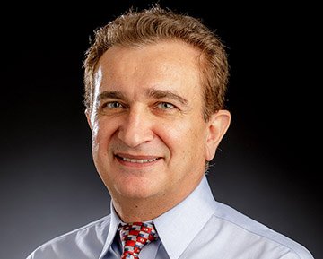
Ahmed Ismail, PhD, PG
President & Principal Geophysicist
Dr. Ismail is a seasoned professional with more than 25 years of extensive experience in the field of geophysics. He has successfully undertaken and completed over 100 impactful projects centered around critical areas such as geotechnical investigations, geological assessments, environmental analyses, groundwater studies, archaeological explorations, and oil exploration endeavors. With a wealth of expertise in the field, he boasts an impressive background in utilizing a multitude of geophysical techniques for data acquisition, processing, and interpretation. His proficiency extends to an array of cutting-edge methods, including, but by no means limited to seismic reflection and refraction, MASW (Multichannel Analysis of Surface Waves) and ReMi (Refraction Microtremor). Furthermore, he is well-versed in downhole seismic investigations, electrical resistivity surveys, and the application of IP (Induced Polarization), SP (Self-Potential), electromagnetic, and magnetic methods.

Neil Anderson, PhD
Chief Scientific Advisor
Dr. Anderson is a professor emeritus in geological engineering at Missouri University of Science & Technology (formerly UMR). He is internationally recognized for his expertise in engineering geophysics. Neil routinely acquires shallow geophysical data in support of geotechnical, geohydrologic, structural, pavement, bridge deck, utility and archeological investigations. His crews utilize the following tools: electrical resistivity tomography (land and marine), induced polarization, self-potential, ground conductivity, metal detectors, ground penetrating radar, surface waves (MASW and ultrasonic), impact echo, pachometers, reflection seismic, refraction seismic, echo sounding, sub-bottom profiling, and sidescan sonar. Neil worked for ten years in the oil and gas industry.

Chris Stohr, PhD Engineering Geologist
Dr. Stohr is a retired Engineering Geologist from the Illinois State Geological Survey. He has over 30 years of experience in applied research, consulting, university teaching, and international project management.
Areas of expertise include:
Environmental and Engineering Geology - waste management, natural hazards, mapping.
Remote Sensing - landfills, industrial site selection, Level 1 and 2 PESA, outcrop and mining
Remote Sensing - aerial, space, & terrestrial; VNIR, multispectral, thermal imagery
Image Processing - enhancement, classification, manual and machine analysis
Data Analysis- GIS, geodetic surveying, and mapping
Close-range photogrammetry and lidar - outcrop and mine face mapping for CO2 and groundwater
Agronomy - dredged sediments use for brownfield restoration
Coastal - measure historical bluff line erosion by aerial photogrammetry, artificial reef sitting
Natural Hazards Mapping - landslides along Ohio and Mississippi Rivers and geologic conditions
CO2 Sequestration - leakage from CO2 geologic sequestration by thermal IR signature of plants
Landfills and Waste Management - municipal, radioactive, hazardous waste; groundwater studies
Rifat Bulut, PhD Geotechnical Engineer
Dr. Bulut, a faculty member at Oklahoma State University, is recognized for his contributions to the highly specialized field of expansive soils. He has made significant contributions to the foundations and pavements built on problematic soils. Dr. Bulut brings a wealth of experience in geotechnical engineering. With years of expertise under his belt, he is poised to make a significant impact on our projects. His vast knowledge and hands-on experience in dealing with complex geotechnical engineering problems, expansive soils, slab-on-ground foundations built on expansive soils, and soil-structure interaction, he will undoubtedly prove invaluable in ensuring the success and reliability of our endeavors. We are thrilled to have him on board as one of Maximum Geophysics Consultants and look forward to witnessing the transformative influence of his contributions within our team and throughout our company. His technical expertise in the field of geotechnical engineering includes (but not limited to):
design recommendations for expansive soils and their impact on existing and new foundations and pavements
water movement and drainage conditions for residential and commercial building foundations, and pavements on expansive soils
failure analysis of structural and foundation construction, and evaluation of engineering investigations
post-tensioned slab recommendations (PTI method), and soil suction

Jim Puckette, PhD, Geologist
Jim Puckette is Professor Emeritus in the Boone Pickens School of Geology at Oklahoma State University (OSU). Jim specializes in physical stratigraphy, sedimentology and petroleum geology. Prior to joining the faculty in 2000, he was an exploration geologist working for small independent companies that operated mostly in the northern and central Oklahoma. A native of eastern Oklahoma, Jim has championed studies related to Oklahoma’s water and oil and gas resources. He is presently involved in conventional and unconventional oil and gas reservoir studies, including the Hunton Group, Caney Shale, Mississippian carbonates and Pennsylvanian sandstones and carbonates. His interest in water resources resulted in his participation in studies of the Arbuckle, Simpson, and Boone bedrock aquifers and alluvial and terrace aquifers along the Arkansas River. He has mentored 73 M.S. and 2 Ph.D. graduates. He also mentors undergraduates, including 6 Wentz scholars, 2 honors theses and numerous undergraduate research projects. In addition to his collegiate instruction and research, Jim is active in outreach through in-service teacher training and programs for school and youth groups. Jim thrives on teaching and fieldwork and was the OSU Les Huston Geology Field Camp Director near Cañon City, Colorado for over 25 years.

Andrew Stumpf, PhD, Geologist
Dr. Stumpf is a licensed geologist who brings a wealth of experience in geologic mapping and subsurface characterization to our company. He has over 25 years of experience working with geophysicists, and internationally recognized for his expertise on engineering geology, aquifer characterization, and geothermal energy projects. Working on collaborative projects, data collected from a variety of surface and borehole geophysical methods is used to map depositional features and structural elements in unconsolidated (glacial) materials and sedimentary bedrock. He brings these congruent datasets together to develop 3D models and simulations.

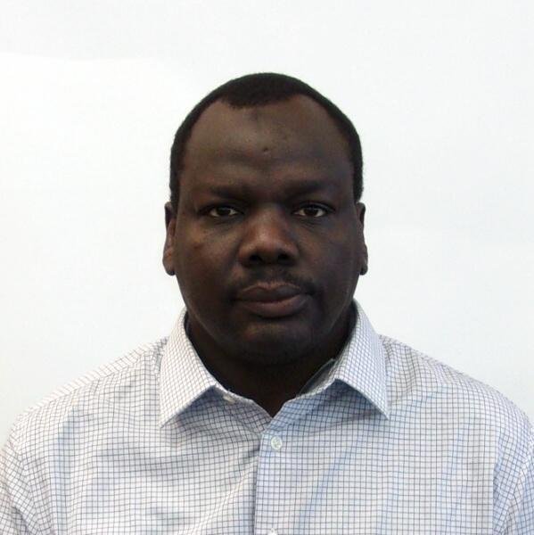
Osman Hassan, PhD, Petroleum Geophysicist
Dr. Hassan is a Sr. Petroleum Geophysicist with more than twenty plus years of diversified experience in the oil and gas industry from Trace to Target. Areas of technical expertise include 3D depth imaging, model building, updates, and depth conversion. Salt interpretation for PSDM velocity model building. FWI scenario testing, detailed QC, and Asset Development. Worked on and coordinated multiclient and propriety projects such as GOM Walker Ridge-WAZ, Garden Banks WAZ, Rev04, 05, and Coil data in East Breaks West GOM. Also, worked on Campeche South GOM 3D data on the Mexico side and offshore Brazil using well data and gravity data when available. Interpreted Supra and Sub salt possible targets identifications and the carbonates /basalt challenges. Fully comprehend and taught the seismic reflection cycle from modeling, acquisition, processing, interpretation, and inversion. In Time, Frequency, and Depth domains, Narrowband- Broadband data. Understands petroleum systems, salt tectonics, and related sediments interactions. Possess strong technical background and understanding of geophysical techniques from trace acquisition to prospect generation such as Amplitude VS Offset (AVO), Attributes Analysis, inversion, Spectral Analysis, and Seismic Stratigraphy. Experience working with geosciences technologies for prospect generation and integrated multi-discipline workflows, seismic data interpretation, seismic attribute extraction as well as seismic data conditioning, velocity models building for PSDM, QC, and seismic synthetics generation. Good working knowledge and support/trains/testing of Paradigm’s depth imaging software and velocity updates, Probe AVO and inversion, Geo Frame IESX, and Landmark/graphics geophysical products such as GES Explorer, PRIZM, and Seis Vision.

Omar Amer, PhD, Geotechnical Consultant Engineer
Dr. Amer has been working in the engineering consulting industry since 2005. Over the years, his duties included preparation and reviewing geotechnical site investigation reports along with their engineering analysis, design of shallow and deep foundations, design of strutted and anchored side-support systems, design of MSE walls, and geotechnical forensic studies. He has been involved in a wide array of project types from small-scale to mega-scale including commercial and residential projects, medical, storage tanks, gas plants, gas compressor stations, electrical plants & substations, communication towers, roadways, bridges, HDD pipelines, water and wastewater treatment plants, solar power plants, canal lining, archeological, etc. In Maxima Geophysics, his duties include analysis for geotechnical engineering purposes for data acquired from Ground Penetrating Radar (GPR), Shallow Seismic Refraction (SSR) using MASW, Vertical Electrical Sounding (VES), Electrical Resistivity Imaging (ERI), and thermal conductivity.
Souleyman Madallah, Geophysicist
Mr. Madallah is a junior geophysicist with a robust foundation in geology, brings a wealth of experience to the realm of subsurface exploration. His journey began with a bachelor's degree in geology, which laid the groundwork for his seamless transition into the dynamic world of geophysics. With years of hands-on experience as a geophysicist, Mr. Madallah wields a diverse toolkit that includes an array of powerful techniques. From the intricate measurements of resistivity, which unveil the hidden electrical signatures of underground formations, to the strategic deployment of seismic waves that divulge the secrets of subsurface structures, his adeptness in these methodologies is unparalleled. Additionally, his mastery of ground-penetrating radar (GPR) empowers him to harness electromagnetic pulses to reveal shallow features and enigmatic relics.
For a Consultation or Scheduling a Training
Call us at: (945) 400–8316
Interested in working together? Fill out some info and we will be in touch shortly! We can't wait to hear from you!